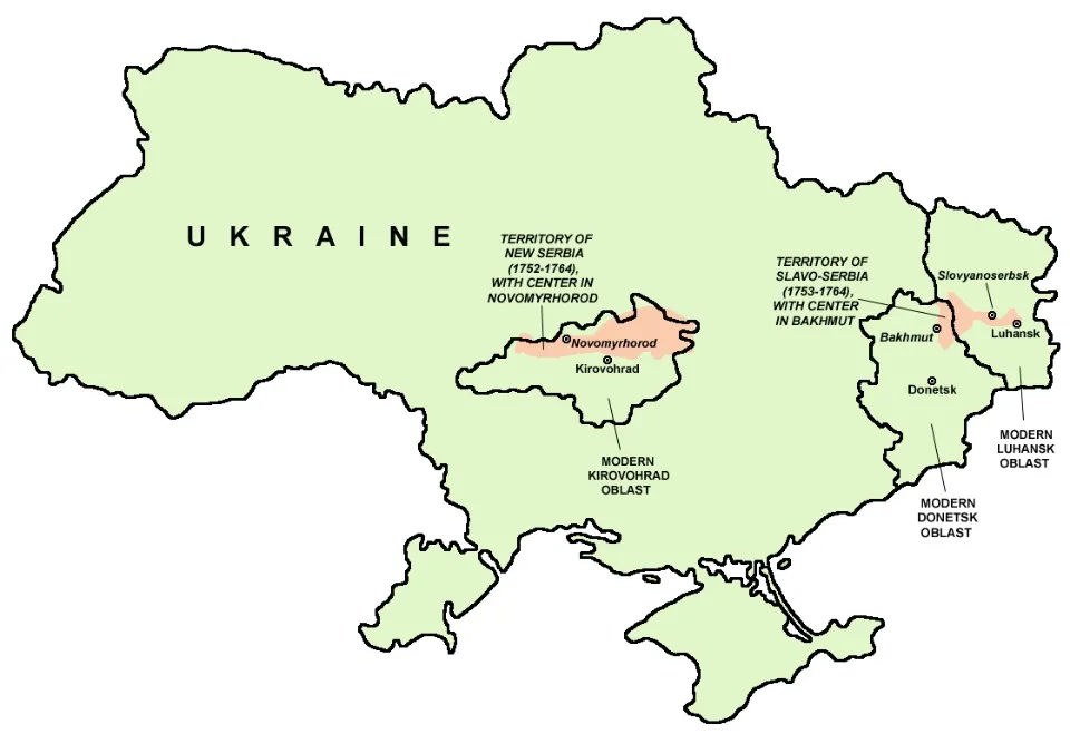
Slovianoserbia was an administrative-territorial military unit formed by the Russian government in 1753 to the south of the Siverskyi Donets river between its tributaries Bakhmutka and Luhan. Liquidated in 1764, it bordered on the land of the Don Army to the east, the Zaporizhzhia Lowland Army to the west, the Slobozhanshchyna to the north, and the Crimean Khanate to the south.
In an article for “TRIBUN”, historian Valerii Negmatov explored the formation of Slavo-Serbia.
Background: Valeriy Negmatov is a historian from the city of Sievierodonetsk, specializing in historical memory, and as a local historian he has been studying his native region for his entire life.

What is Slavo-Serbia?
We can distinguish two periods in the history of Slavo-Serbia. The first: 1753-64 - its formation as a special administrative and military region with the presence of foreign colonists, which had some form of autonomy; second: 1764-83 - the loss of its privileged status and its inclusion in the general imperial administrative-territorial division of Russia, attempts to increase the combat capability of the hussar regiments and their liquidation in 1783. With the creation of the Novorossiysk province in 1764, the concept of "Slavo-Serbia" lost its practical significance and exists as a component of regional historical memory.
The history of the settlement of Slavo-Serbia is connected with the appearance of Zaporizhzhia Cossacks' guard posts in the territory between the Luhan and Siverskyi Donets rivers in the 16th century. The first mention of the existence of such a post in Pidhorne (present-day Slovianoserbsk) dates back to 1740. The intensive settlement of this region dates back to the 50s and 60s of the XVIII century. Serbs, later Bulgarians, Moldovans, and Poles moved here, with the permission from the Russian government, to fertile lands that had not yet been plowed, and Serbian colonels Jovan Šević and Raiko Preradović formed foot and horse regiments. These units were to guard the southern borders of the Russian state from attacks by Turks and Tatars. The territory between Luhan and the Siverskyi Donets was called Slavo-Serbia. Following the military settlers, peasants from Kharkiv, Chernihiv, Kursk, and Smolensk provinces, as well as traders from different parts of Russia, who were attracted by the favorable terms of trade, began to move to Slovianoserbia.
Administrative and territorial structure
From 1753 to 1764, Slavo-Serbia existed as an autonomous unit with its center in the city of Bakhmut and was subordinated to the Senate and the Military Collegium. In connection with the reorganization of Serbian military regiments in 1764, Slovianoserbia became part of the Catherine II province of Novorossiysk, and from 1802 - part of the Ekaterinoslav province.
The settlement of Slavo-Serbia was carried out by companies. Some of them settled near existing settlements at the time. The Cossacks lived in Vergunka and Kamianyi Brod (on the site of modern Luhansk) since the 17th century, as well as in Cherkaskyi Brod (now Zymohiria); in Pidhirne (now Slovianoserbsk) since the 40s of the XVIII century there were winter quarters and farms of the Zaporozhian Sich. The village of Kalynivske (now Kalynove village of Popasna district) has been mentioned in documents since 1720. The sconce of the 5th company was named Assessor's from an existing hamlet, but after a while it was called Pryvilne. During the existence of Slavo-Serbia, some companies changed their location, but most of them remained in place. Therefore, to this day, old residents sometimes use the name of the company instead of the name of the settlement.
In the Bakhmut Hussars Regiment, some companies were liquidated, reorganized, and given different numbers. Now the companies were located as follows. On the right bank of the Donets River were: Company 1 in Serebryanka, Company 5 in what is now Pryvillia, and Company 3 in Verkhne. The same company also occupied the site of the former 8th Company, which is now Bila Hora. The 7th Company was stationed in Nyzhne. Then came the 6th Company (Krymske village), the 8th Company in Pidhirne (later Donetsk and Slovianoserbsk), and the 9th and 10th Companies along the Donets. On the river Lugan from the bottom up: Company 2 - Vergunka village, Company 4 - near the mouth of the Olkhova River, Company 11 - near the mouth of the Bila Luhan river, and Company 12 behind it. The 16th company was located on the Komyshuvakha river. Further up the Luhan river were the 13th and 14th companies. Even higher, not far from the place where the Skelevata river flows into the Luhan, was the 15th company (Luhansk, Donetsk regions).
According to the documents of that time, foreign colonists received land for life, a salary (from 32 rubles for a private to 836 rubles per year for a colonel), assistance for settling down, a pension, and benefits for crafts and trade. Difficulties in developing the land were exacerbated by Russian bureaucracy, officers' self-interest, unusual conditions of service and management, conflicts with the local population, and the colonists' reluctance to fulfill the tasks assigned to them by the government.
Serbian settlers had previously done little farming and had lived from generation to generation through military service. The Serbs themselves emphasized that they were good soldiers, but they had little knowledge of agriculture. Therefore, farming was of a low level. But over time, they learned from the local population how to cultivate the land. They sowed mostly rye and wheat, less oats, barley, millet, buckwheat, flax, and hemp. The Balkan settlers were better at animal husbandry. Breeding of horses, cattle, and especially oxen as the main traction force was widespread. Over time, sheep farming took a significant place.
Along with the economy, trade developed, including foreign trade, because it was a borderland. An important form of domestic trade was the fairs of the time, which were attended by merchants, as well as сhumaks, townspeople, and peasants from the Slobozhanshchyna, Zaporizhzhia winter quarters and nearby Russian cities. In addition to fairs, trades and bazaars were constantly held in Slavo-Serbia, and the number of small shops grew.
The contribution of local historians to the study of Slavo-Serbia
At the request of the Sievierodonetsk researcher Serhii Kaleniuk, the director of the Mining Museum, Yurii Kostrytsia, obtained from the Moscow archive the "Reliable Land Map of Slavo-Serbia of 1750". It turned out that most of the settlements where the regiment's companies were stationed had already existed before the Slavo-Serbs arrived. Together with Mykola Lomaka, Kaleniuk wrote a book in 2010 called “Companies of the Depraradovic Regiment: Travels in the Lysychansk Area in Search of the First Settlers”. According to Kaleniuk, no one has done more than Lomako in the cartography of Lysychansk and its surroundings and probably never will. In the course of his work, he created a map of Slavo-Serbia that had completely different outlines of the territory than the map of 1750: the territory reached not the boundaries of Luhan, as it was written in the Senate decree, but Luhanchyk, and the location of the companies was better marked. Serhii Kaleniuk considered this map by Mykola Lomako to be a scientific achievement.
The legacy of Slovianoserbia
The first is the military aspect. The two regiments created were intended to protect the southern borders of the Russian Empire from the raids of the Crimean Tatars.
The second is the confessional one. Balkan settlers were Orthodox, as was the local population. This, on the one hand, contributed to the adaptation of the settlers, and on the other hand, did not allow them to avoid conflicts with the locals.
The third was the control of our lands by foreigners. The Russian Empire was not entirely satisfied with Ukrainian colonization. It wanted to adjust it in terms of direction, controllability of processes, taking into account the interests of landlords, and so on.
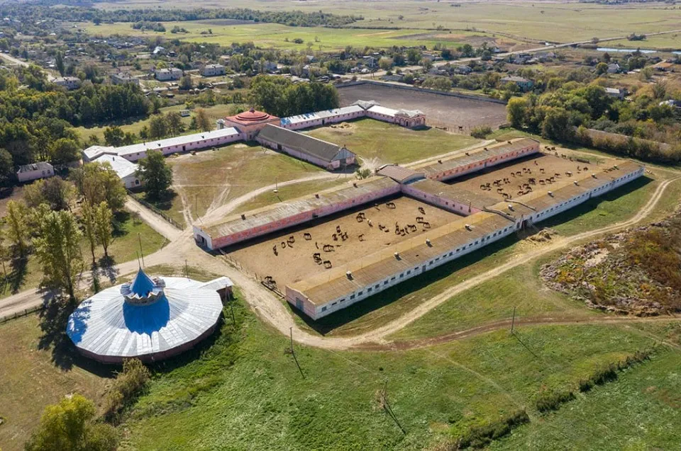
The fourth is the development of animal husbandry, the cavalry traditions. That is, horse farms in Luhansk region are, in a way, a legacy of the Serbs.
The fifth is agriculture, or rather growing of vegetables: bell peppers, eggplants and other vegetables.
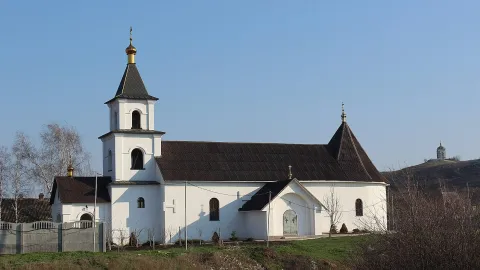
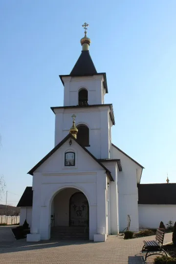
The sixth is the Serbian architectural tradition of some churches, the differences in Serbian crosses. The military settlers tried to build a church in each company. Already in 1754, a church in a wooden house was consecrated in the village of Pidhirne (Slovianoserbsk), and in 1784 a beautiful stone church was consecrated. In 1761, a wooden church of St. Peter and Paul was built in the Kamianyi Brid chanter, in 1762 a church was opened in the village of Verkhnye, and 2 years later a church was founded in the village of Nyzhnye. In total, by the early 60s of the eighteenth century, there were more than 30 churches in Slavo-Serbia.
The seventh is the origin of surnames. The most common surname found in company lists today is probably Voloshyn. Those of our countrymen who have the surnames Božić, Vukotić, Voloshyn, Gustov, Baronin, Serbyn, Serbynenko, Serbulov, etc. can look for their ancestors among the same Slavs who founded the companies over the Donets.